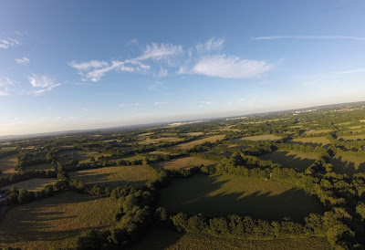
A set of images taken on 29 June and 4 July 2015 in the countryside between Horsham and Crawley
Click on any image to view in greater detail
SET ONE - Taken from near the Rusper Road roundabout North of Horsham
Looking north towards Rusper, with Rusper Road going up the middle of the picture. The white buildings on the horizon to the right of the picture is Gatwick.
Looking west towards Warnham
Looking out across Horsham. The Rusper Road roundabout is just to the right of the centre of the picture
Looking slightly Eastwards from the previous picture. The Moorhead roundabout is towards the left at the picture at the end of the road. The Holbrook Club playing fields can be seen towards the right of the picture and the new St Marks Spire on the far right.
Looking North East towards Crawley. Faygate is in the centre of the picture with Gatwick again visible
Don't look down!
SET TWO - Taken from the brow of the first big hill as head towards Rusper from Horsham
Looking north, Gatwick is once again visible on the right of the horizon.
Looking East(ish), Gatwick is on the far left, then Crawley's industrial area, followed by the town centre (ICC, the hospital and the college are all clearly visible). The next easily identified areas are the Kilnwood Vale development (see http://aerialbritain.blogspot.com/2015/06/six-pictures-kilnwood-vale-development.html for closer aerial images of this estate) then Faygate. On the far right of the image is the outskirts of Horsham
Looking south over Horsham
Looking west towards Warnham
Don't look down (again)! The line of trees bordering the right of the field marks Rusper Road
SET THREE - Taken from a field off Green lane, which links Rusper Road with Langhurst Wood Road (near the brickworks and landfill site)
Looking South over Horsham (and including a crop circle). The road on the bottom left is the Rusper to Horsham road
Another shot encompassing Gatwick (to the left), the outskirts of Horsham (to the right) and everything in between with the Rusper to Horsham road running along the bottom of the image.
Looking North towards Rusper, which is obscured by trees.
Looking West towards Warnham, with the quarry in the centre of the left half of the pic.
Looking South East, with Horsham to the left and the quarry to the right. And there's that crop circle again!
SET FOUR - taken from the Rusper end of Wimlands Road
Looking North towards Rusper, which is still obscured by trees. Crawley college and hospital are both visible on the right of the image
Looking eastwards, Kilnwood Vale is visible just to the right of centre (or below left of the moon, if you've spotted the moon!)
Looking south towards Horsham
Looking West into the sun. The junction of the Rusper to Horsham Road and Wimlands Road is in the centre of the image.
SET FIVE- taken from near the Lamb pub in Lambs Green
Looking North towards the airport
Looking East towards Ifield West. Kilnwood Vale is to the right of the moon this time and The Lamb is at the bottom of the image.
Looking south towards Horsham. The Lamb is now at the bottom left.
Looking west towards Rusper and the Surrey Hills
SET SIX- taken from CottesmoreSchool
Looking North East across Broadfield and Crawley
Looking South East towards Pease Pottage (left of centre)
Looking South West towards Colgate and Horsham. Kilnwood Vale is on the far right
Looking North West Across the West of Crawley. Kilnwood Vale is on the far left and Ifield West, Bewbush, Gossops Green and Broadfield are all visible.


...And in those fields in ancient times... England's green and plesant land, but for how long??
ReplyDelete